
August 15, 2025
Trail Relocation, Falls Village
Mohawk Trail
Relocation
November 15, 2024
Trail Relocation- Johnson Rd
Mohawk Trail
New, Relocation
July 13, 2022
Dark Entry Road- Trail Closure
Mohawk Trail
Closure
Details
Trail Length: 24.3 miles
Towns: Cornwall, Goshen, Cannan
Allowed Uses: Hiking Only
Partners: Connecticut Department of Energy & Environmental Protection (CT DEEP)
Trail Overview
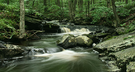
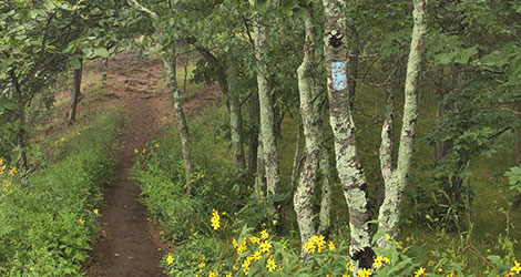
The Mohawk Trail, established as a Blue-Blazed Hiking Trail on May 8, 1988, follows the former eastern route of the Appalachian Trail. The AT was relocated west of the Housatonic River between Route 4 and Falls Village. The Mohawk Trail crosses Mohawk Mountain and Housatonic Meadows State Parks and the Mohawk, Wyantenock, and Housatonic State Forests. From its southern junction with the AT on Breadloaf Mountain, the trail crosses the Housatonic River and traverses multiple peaks 1,200 feet or higher in the Litchfield Hills (from Coltsfoot Mountain in Cornwall to Barrack Mountain in Canaan), and ends at the AT on the Warren Turnpike near the Regional High School in Falls Village. The Mohawk Trail intersects the Mattatuck Trail on Mohawk Mountain in Cornwall. Distinctive features such as Cathedral Pines, Mohawk Mountain, Red Mountain, Dean Ravine, and Lookout Point on Barrack Mountain, as well as spectacular views from many points along the trail, make it a popular hiking destination.
Four overnight backpacking shelters on the Mohawk Trail offer hikers the opportunity to enjoy the trail for overnight trips. These shelters are maintained by the CT DEEP. Please contact the CT DEEP Western District office for reservations or if you have questions about shelter availability. Backpackers often enjoy connecting the Mohawk and Appalachian Trails for an extended, multiple-night loop trip.